Worlebury Camp Hillfort

Aerial photo of the Worleburry hilltop fort showing the area

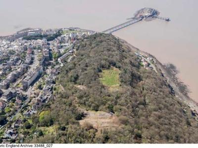
Worlebury Camp is an Iron Age hillfort that occupies 10 hectares of land at Worlebury Hill, a site that overlooks Weston Bay, Sand Bay, and the Bristol Channel. 

It has been designated a scheduled monument since 1915, and is a nationally important archaeological site due to its rare coastal location, size and considerable defences.

The hillfort is mostly hidden by trees that were planted in the 1820s, but before the 19th century the hillfort would have been visible for miles around. 

Structure of the hillfort

Hillforts are defended settlements – mostly found on hilltops – that are surrounded by circuits of banks and ditches.

Worlebury Camp boasts a set of seven banks and ditches on the eastern ramparts. The ramparts were constructed with a series of dry-stone walls which acted as support for additional defence, with a wooden fence on top.

These walls now appear as huge heaps of tumbled stones and are mostly visible at the eastern ramparts. The cliff at the northern side of the hillfort would have been used a natural line of defence.

Archaeological studies

Worlebury Camp has had a number of archaeological studies, with excavations recorded in 1851 by Reverend F. Warre and in the 1880s by C.W. Dymond. These investigations identified 93 pits, as well as pottery vessels, bone, wood and antler tools, and even human burials. Other features such as entrances and large ditches were also recorded.

The 93 pits were stone-lined, and grain such as barley, wheat and oats were recovered, suggesting that these were used for storage. Some of the pits contained skeletons and it has been suggested these were ritual burials.

What we're doing today

The hillfort was added to the heritage at risk register in 2016 because of harm that was being caused to the monument through such issues as vandalism, tree and vegetation growth, and fly-tipping.

We’re working with volunteers of the Worlebury Hillfort Group and other local interest groups to raise awareness of the importance of the hillfort and to resolve these issues by implementing a management plan for the site.

The volunteers have been clearing unwanted vegetation from parts of the inside of the hillfort and have exposed some of the pits for people to see. Our contractors cut back the eastern ramparts every year.

In 2017 we were successful in a £10,000 bid from the Heritage Lottery Fund to carry out an archaeological condition survey of the hillfort, which has helped us create the below management plan.

Visiting the hillfort

Visiting Worlebury Camp is free, and we encourage people to take in the beautiful views across to Sand Point and Brean Down, as well as the panoramic view of Weston Bay.

There are a number of ways to get to Worlebury Camp.

  1. Park at Weston Woods car park (Worlebury Hill Road, BS22 9SG) and follow an accessible path to the eastern ramparts
  2. Through a public right of way that runs through the hillfort towards Kewstoke Road, but be aware this is currently uneven due to the stones and tree roots, so please take care.
  3. Via a bridle path up from Kewstoke Road (BS23 2ES), which takes you to the base of the eastern ramparts, and Trinity Road steps.
  4. By steps from the Birnbeck end of Camp Road (BS23 2EN)
  5. From the town quarry path.

More information

If you would like to find out more about how to become involved in the project, email our archaeologist below or visit the Worlebury Hillfort Group on Facebook.

You can also visit Weston Museum in Burlington Street, Weston-super-Mare to discover more about the hillfort and the artefacts that were recovered during the excavation.

Council Archaeology team